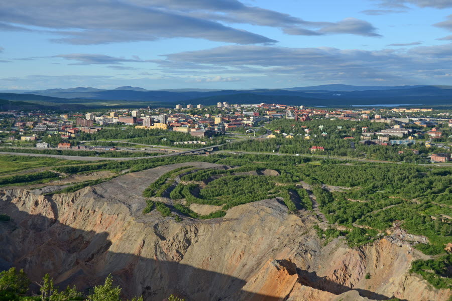
Framför er ser ni gruvberget Kiirunavaara och den grop som varje dygn kommer 11 cm närmare, vilket blir 40 meter om året. Vägen till gruvan gick tidigare här vid denna utkiksplats men stängdes 2013 då den flyttades norrut. Räcket kommer från gamla stadshuset och nedanför er ser ni stängslet till deformationsområdet.
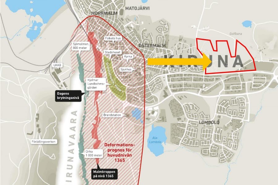
Gruvans utbredning, på såväl djupet som bredden, har blivit mycket större än vad någon kunde tro när samhället Kiruna planerades en gång i tiden. Nu flyttar delar av staden och byggs upp på nytt cirka tre kilometer österut.
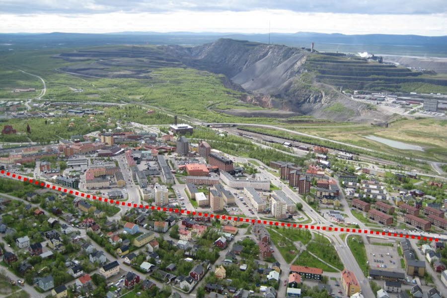
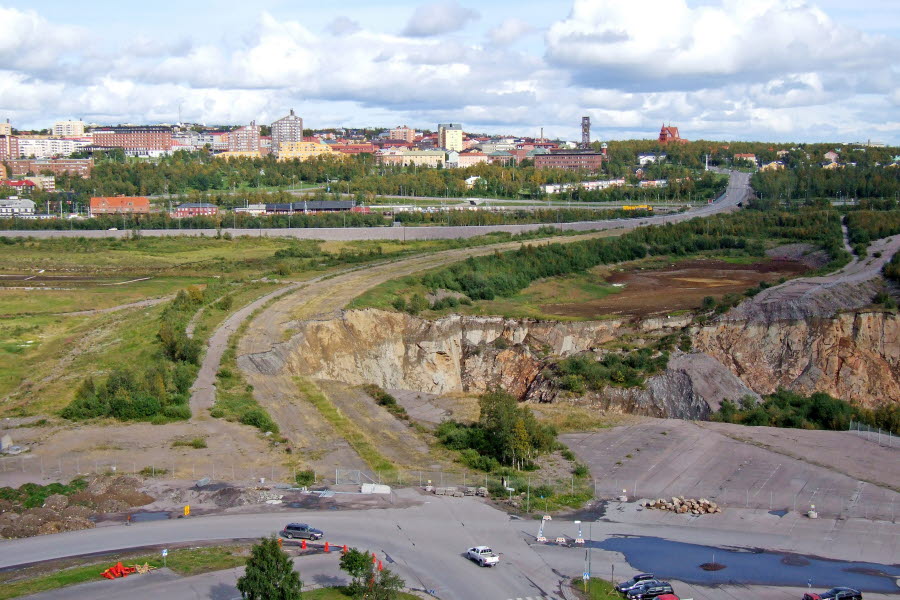
På bilden ovanför och på kartan med QR-promenadens sträckning ser du en prickad linje för påverkat område. Allt nedanför den linjen påverkas av dagens huvudnivå i gruvan, med andra ord hela det område du kommer att promenera genom nu.
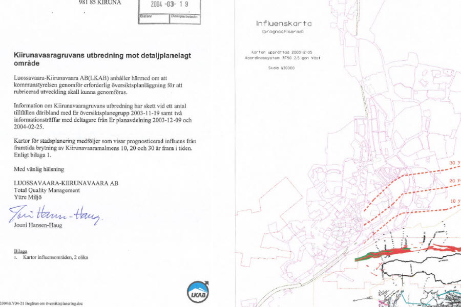
År 2004 meddelade gruvbolaget LKAB i ett brev till Kiruna kommun att gruvbrytningen kommer att påverka stadsbebyggelsen inom en åskådlig framtid. Detta satte igång det vi nu känner som stadsomvandlingen.
Berörs fram till år 2035
Cirka 3000 lägenheter, 200 villor, 400 hotellrum och 200 000 kvadratmeter allmänna ytor och byggnader berörs av stadsomvandlingen fram till år 2035.
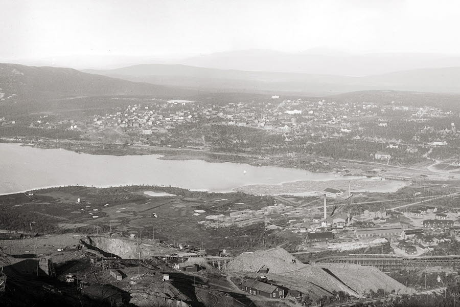
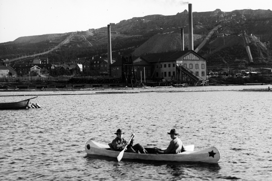
I ett större perspektiv har Kiruna hela tiden varit i förändring. Ut ur inget anlades en stad och redan under 1950-talet började gruvans utbredning påverka Kiruna. Sjön Loussajärvi, som tidigare låg nedanför er, är idag endast en tredjedel av sin forna storlek. Under 1950-talet tömdes första delen och sedan har sjön minskat i etapper.
Stadsdelen Ön växte fram vid Kiirunavaara i början av seklet men avvecklades under 1970-talet. Här fanns bostäder, samhällsservice och industrier. År 2006 stängdes området helt och idag är marken där Ön låg borta.
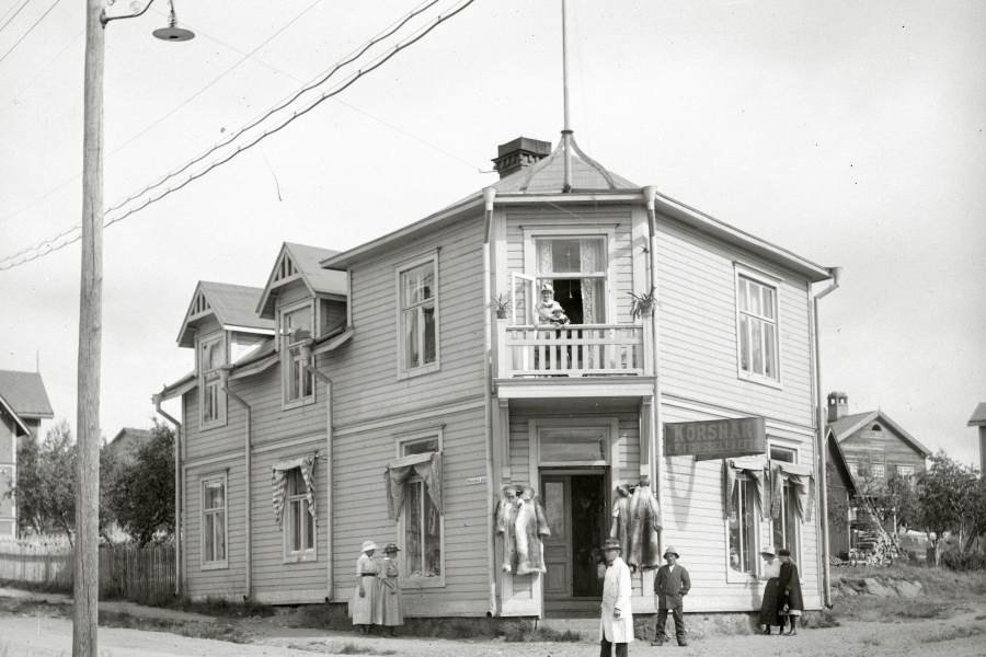
Likt andra stadskärnor i landet förändrades även Kiruna drastiskt under den så kallade centrumsaneringen under 1950-70talet. Enligt en saneringsplan skulle allt äldre än 1920 rivas och ersättas med nybyggnation. Riktigt så blev det inte men hela Kiruna förändrades.
Viktiga årtal
- 1950-tal - Loussajärvi börjar tömmas
- 1970-tal - Bostadsområdet Ön rivs.
- 2004 - Kommunen får veta att stadskärnan kommer påverkas.
- 2007 - En första översiktsplan över nya Kiruna är klar. Tidsplaner för flytt och avveckling av byggnader uppdateras kontinuerligt när förutsättningarna ändras.
- 2008 - Gruvbolaget LKAB beslutar om ny huvudnivå, KUJ 1365. Detta betyder att brytningen sker djupare än tidigare, 1365 meter under jord. Enligt denna brytning påverkas staden fram till år 2035. Huvudnivån sattes i drift 2017.
- 2013 - Förslaget Kiruna 4-ever vinner tävling för ny stadsplan.
- 2013 - Vägen du står vid nu stängs och ny väg öppnades längre norrut.
- 2013 - Ny järnväg och tillfällig station börjar användas.
- 2014 - Bostadsområdet Ullspiran blir första område efter brevet att rivas.
- 2017 - Första kulturbyggnaderna flyttas.
- 2017 - Järnvägsstationen rivs.
- 2018 - Första byggnaden i nya stadskärnan står klar, Kiruna nya stadshus Kristallen.
- 2019 - Gamla stadshuset rivs.
- 2021 - Första bostadskvarteret i nya stadskärnan står klar.
- 2022 - Nya centrum invigs.
The urban transformation begins
In front of you, you can see the Kiirunavaara mining mountain and the pit that comes 11 cm closer every day, the equivalent of 40 metres a year! The road to the mine used to pass by this lookout point but it was closed in 2013 when it was moved northwards. The railing comes from the old Town Hall and below you can see the deformation area’s fencing.
Both the width and depth of the mine have grown much more than anyone could have imagined many decades ago when the town of Kiruna was planned. Now parts of the town are being moved and rebuilt about three kilometres to the east.
In the picture above and on the QR walk map, you can see a dotted line which marks out the affected area. Everything below that line is affected by today's main level in the mine, in other words, the entire area you are now going to walk through.
In 2004, the mining company LKAB sent a letter to Kiruna Municipality informing them that mining operations are going to have an impact on the town area in the foreseeable future. This initiated what we now call the transformation of the town.
Affected areas up until 2035
Approximately 3,000 flats, 200 houses, 400 hotel rooms and 200,000 square meters of public areas and buildings will be affected by the transformation of the town up until 2035.
In a larger perspective, Kiruna has always been in a process of change. The town was created from nothing and even in the 1950s, the expansion of the mine had begun to affect Kiruna. Lake Loussajärvi, which used to be below you, is now just one third of its former size. During the 1950s, the first part was emptied and then the lake has decreased in stages.
The Ön area started to develop by Kiirunavaara at the beginning of the 20th century but was gradually closed down in the 1970s. The area had housing, public services and industries. In 2006, the area was completely closed off and today the land where Ön was once located is no longer there.
Like other town centres in Sweden, Kiruna underwent drastic changes during “town centre clean-up” operations during the 1950s-1970s period. According to a clean-up plan, anything older than 1920 was to be demolished and replaced with new buildings. That was not exactly what happened in Kiruna but the whole of the town was changed.
Important years
- 1950s - The emptying of Lake Loussajärvi began.
- 1970s - The Ön housing area was demolished.
- 2004 - The Municipality was informed that the town centre would be affected.
- 2007 - The first detailed plan of the new Kiruna was completed. The schedules for the moving and closing down of buildings have been continuously updated as conditions change.
- 2008 - The mining company LKAB decided on a new main level: KUJ 1365. This meant that mining would take place at a lower level than before: 1,365 metres underground. Mining at that level will affect the town up until 2035. The main level was put into operation in 2017.
- 2013 - The Kiruna 4-ever proposal won the competition for the new town plan.
- 2013 - The road you are standing on now was closed and a new road opened further north. More of Lake Loussajärvi was emptied.
- 2013 - The new railway and temporary railway station were inaugurated.
- 2014 - The Ullspiran housing area was the first area to be demolished after the letter.
- 2017 - The first cultural heritage buildings were moved.
- 2017 - The railway station was demolished.
- 2018 - The first building in the new town centre was completed: Kiruna’s new Town Hall, Kristallen.
- 2019 - The old Town Hall was demolished.
- 2021 - The first housing district in the town centre was completed.
- 2022 - The new citycenter was inaugurated.